Compass Bearings Hypothesis
Suns' Azimuth Hypothesis
Expansion-Contraction Hypothesis
Never Go Back Hypothesis
Properties of Magnetic Field
at Field Site
How to Determine Magnetic Declination and Magnetic
Inclination
Magnetic Declination (variation)
Magnetic declination is the difference between the True Meridians and the Magnetic Meridians. This difference reflects the tilt of the earths magnetic field in respect to its axis of rotation. Since the magnetic poles and axis of rotation do not exactly coincide, compass needles do not indicate true North at most sites in the northern hemisphere, or true south at most sites in the southern hemisphere. Most Topographic Maps have a pair of arrows that resemble the hands of a clock in the lower left border that indicate the difference between geographic N and magnetic N for the center of the area shown. Aeronautical Charts, available at or near local airports that give flight lessons, show a more complete picture of magnetic declination. The charts show lines of equal magnetic declination called isogonic lines. The isogonic lines are labeled by the number of degrees east or west the magnetic bearing deviates from the true bearing. An isogonic line with a label of 8°E means that a compass bearing taken in the vicinity of the isogonic line will be rotated 8° counterclockwise of the true bearing. Magnetic Bearings can be converted toTrue Bearings by adding easterly declination and by subtracting westerly declination. In our example, the compass bearing is 222°, the declination (variation) is 8°E, and the true bearing is 222 + 8 = 230°.
Magnetic Inclination (dip angle)
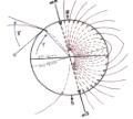
Magnetic inclination is the angle that the geomagnetic field is tilted with respect
to the surface of the earth. Magnetic inclination varies from 90° (perpendicular to the
surface) at the magnetic poles to 0° (parallel to the surface) at the magnetic equator.
The alignment and size of the angle of inclination provide vital information for animals
that use the geomagnetic field for navigation. Animals that have been studied apparently
do not use the N/S polarization of the magnetic field to determine the direction of the
poles. Instead of using the N/S polarization, they use the angle of inclination of the
magnetic field. In the northern Hemisphere, the acute angle that the magnetic field forms
at the surface the earth points towards the North Magnetic Pole. The opposite is true in
the southern Hemisphere. Although the animals cannot tell N from S, they can tell the
direction of higher and lower latitudes. Furthermore, the magnitude of the angle with
respect to the ground provides a rough indication of latitude. For example, the angle of
inclination in is about 72° 24' in region of Toronto, Ontario, and 64°0' in the region
of Atlanta, Georgia.
It is a bit more difficult to obtain the most current information for magnetic inclination
than for magnetic declination. I have a set of 1990 maps and will provide you with the
magnetic inclination of you field site if you provide me with latitude and longitude, the
name of the nearest city, the county, and the State or Province. Send the information by
email (dgibo@credit.erin.utoronto.ca) or by fax (905
828 - 3792). If you would prefer your own charts, you can purchase the appropriate
U.S. Geological Survey Maps at the Magnetic Charts
page. In addition, there are a number of web sites providing excellent information on the
geomagnetic field. Check out the National
Geophysical Data Center in Boulder Colorado. Finally, if anyone knows of other sources
for the magnetic information, please let me know by email, fax, or by posting to tvectors.